Awatchfire

Harney County, Oregon

Buckskin Fire

Burning 21.2 miles north-east of Denio, since Monday 24 August.

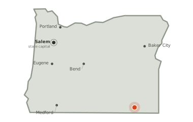
Map of Oregon. The Buckskin Fire burns 177 miles from Baker City and 193 miles from Bend, and 296 miles from the state capital, Salem.
The fire sits 177 miles from Baker City and 193 miles from Bend.

3

acres burned so far

4

days burning so far

no share of the perimeter reported held yet

The official record as of 9:37pm today

The Buckskin Fire is on the interagency wildfire record at 3 acres in Harney County, Oregon. The figures below are the official record. A satellite heat map and day-by-day history appear here as soon as detections are attributed to this fire.

Natural

is the cause on the official record.

4 days

on record — first written down on Monday 24 August at 7:37pm local time, starting at 0 acres.

42.244, -118.407lat, lon

is the official point of origin on the interagency record.

No satellite heat has been attributed to this fire yet — either it is too new for a pass to have caught it, or it is too small to register from orbit. Everything above is from the interagency incident record and updates as that record does.