How the record has moved
Each step is a change on the interagency incident record — acreage, containment or crews — with the date it was reported. No satellite reading is involved.
-
Thursday 3 September
First reported
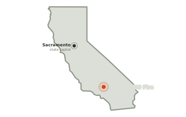
Los Angeles County, California
Burning 7.3 miles north-east of Lancaster and 10.6 miles south-east of Rosamond, since Thursday 3 September.
—
acreage not yet reported
41
days burning so far
—
no share of the perimeter reported held yet
The official record as of 9:09am today
The Lac-316109 Fire is on the interagency wildfire record in Los Angeles County, California. The figures below are the official record. A satellite heat map and day-by-day history appear here as soon as detections are attributed to this fire.
Undetermined
The cause has not yet been determined.
41 days
on record — first written down on Thursday 3 September at 6:48pm local time, starting at 0 acres.
34.763, -118.077lat, lon
is the official point of origin on the interagency record.
Conditions measured 15.7 miles from the fire: 54°F, air at 33% humidity, a 1 mph wind out of the north-west.
Six other fires are burning inside the same view. Lac-334923 Fire started on Thursday 17 September, 0.0 miles north, and has reached an unrecorded size. Lac-343549 Fire started on Wednesday 23 September, 1.0 miles west, and has reached an unrecorded size. Lac-352011 Fire started on Wednesday 30 September, 2.0 miles west, and has reached an unrecorded size. Lac-367292 Fire started on Sunday 11 October, 2.3 miles south-west, and has reached an unrecorded size. Lac-315774 Fire started 292 minutes before this one, 2.9 miles south-east, and has reached an unrecorded size. Lac-313258 Fire started on Tuesday 1 September, 3.0 miles west, and has reached an unrecorded size. Their heat is counted against them, not against this fire, and the pale rings on the map mark where they are recorded.
Smoke has been recorded lying over this ground two times so far. The thickest of it was thin between 1:10pm and 4:30pm local time. The last of those windows closed 185 hours ago, so what is overhead now is not known.
No satellite heat has been attributed to this fire yet — either it is too new for a pass to have caught it, or it is too small to register from orbit. Everything above is from the interagency incident record and updates as that record does.
Each step is a change on the interagency incident record — acreage, containment or crews — with the date it was reported. No satellite reading is involved.
Thursday 3 September
First reported